
This writing will provide you an overview of one of the most spectacular Wilderness of the US, namely Mark O Hatfield Wilderness.
What do you know about Mark O Hatfield Wilderness?
Mother of Nature has brought to the US so many pristine wild areas with breathtaking panoramic views. We have to call a standout place among many spectacular wilderness areas, namely Mark O Hatfield Wilderness.
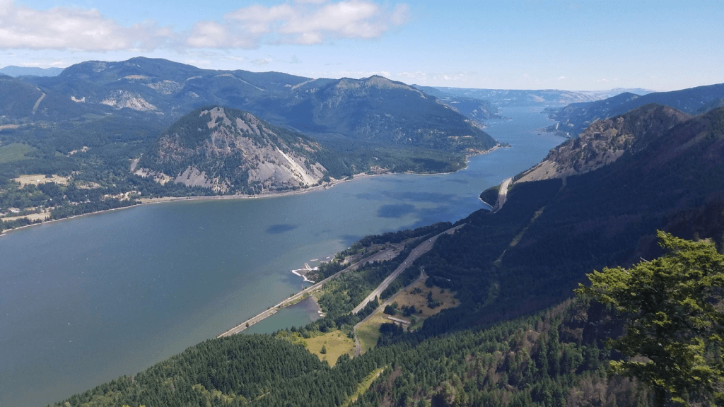
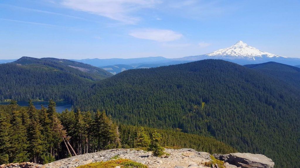
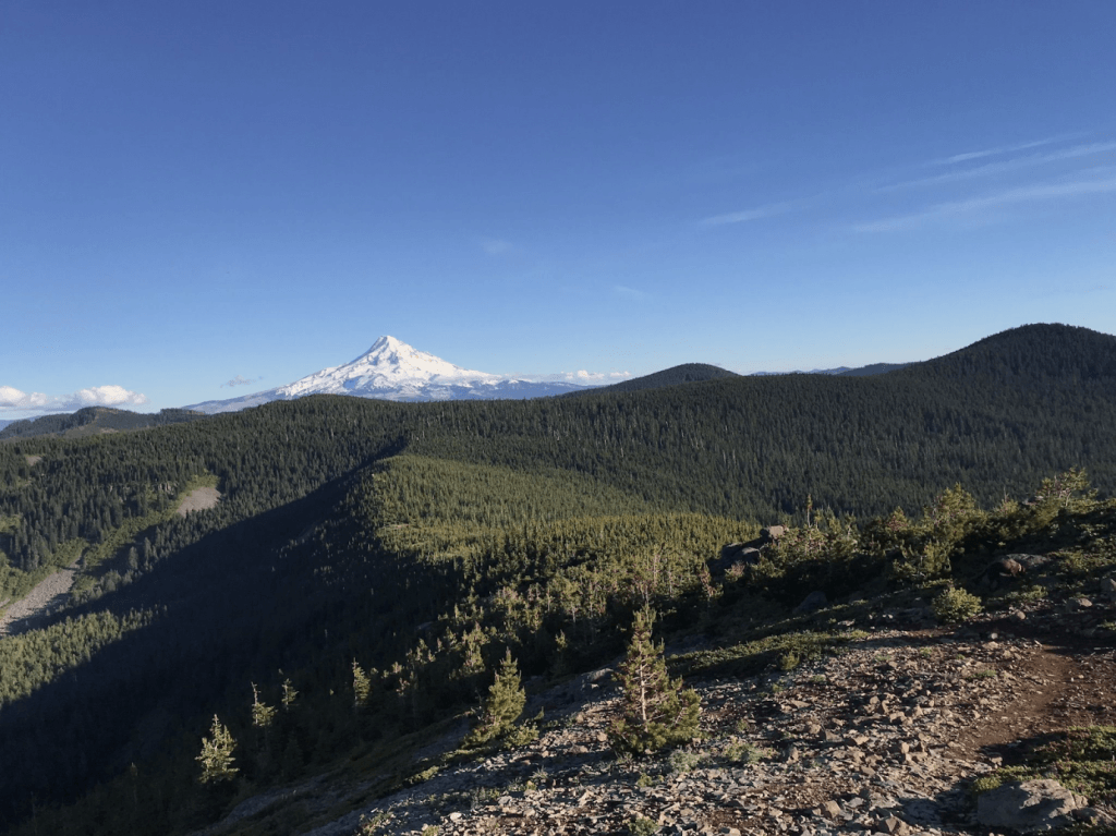
Mark O Hatfield Wilderness lies just south of Columbia River Gorge and between Gorge Face with canyons, cliff, and waterfalls. This Wilderness features a spectacular panoramic view of Cascade Range, a favorite destination of nearby Oregon residents.
This writing will give you a glance at Mark O Hatfield Wilderness, directions, and recreation activities in the Wilderness like BLORA and Mark O Hatfield Wilderness, the trails list that you can choose to explore the wilderness area.
Mark O Hatfield Wilderness Overview
Mark O Hatfield Wilderness
Originally known as Columbia River Wilderness, the Wilderness was renamed after Senator Mark O Hatfield as he was a strong advocate for wilderness areas preservation. However, it is still a controversial issue. As some people thought, his intention of wilderness area preservation served the aim of his political convenience instead of trying to preserve Oregon’s resources.
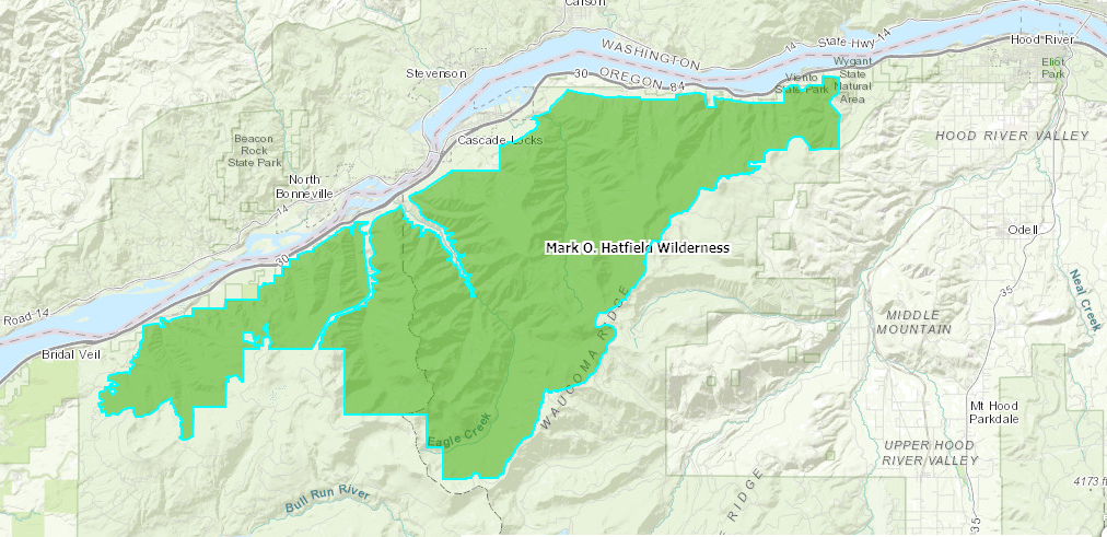
Mark O Hatfield Wilderness is located on Portland’s eastern side, between Mt.Hood National Forest and just south side of Columbia River Gorge National Scenic Area cliffs. Mark O Hatfield Wilderness has a total area of 65,822 acres. US Forest Services manage all of the Wilderness.
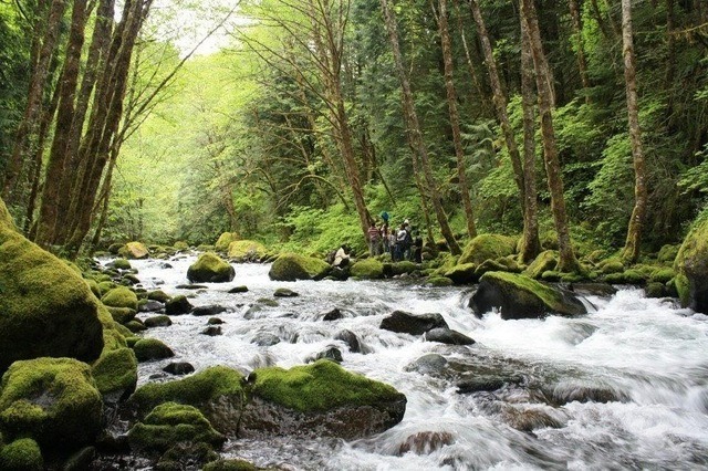
Mark O Hatfield Wilderness is known as the Columbia Gorge Recreation Area before being designated as Wilderness.There are multiple waterfalls, and basalt cliffs characteristic of the Columbia River Gorge presented in the Northern part of the Wilderness.
You can see panoramic views of Columbia River Gorge and the Cascade Range given way by the waterfalls and cliffs when you climb along the river. Also, there are some main waterways that you can find, such as Herman Creek, Tanner Creek, Eagle Creek, follow to the northern side toward the river.
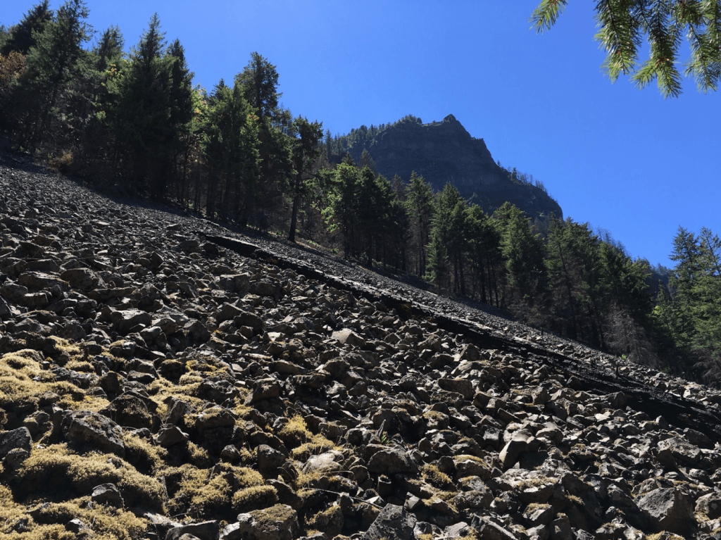
The slope is calculated from approximate sea level the Plateau of Benson and the peak of mountains, lakes, and talus slopes. The Wilderness elevation ranges from nearly 100 feet close to Columbia River to 4,900 feet on Mount Defiance.
How to get to Mark O Hatfield Wilderness?
To get to Mark O Hatfield Wilderness, you can access Wahtum Lake in the Mt. Hood National Forest through the trailheads leading into Mark O Hatfield Wilderness via Wahtum Lake trailhead, Rainy Lake Campground, or Indian Springs.
On the other hand, you can access from the north through Interstate 84 in the Columbia River Gorge within the Columbia River Gorge National Scenic Area.
Mark O Hatfield Wilderness Maps
In 2009, Mark O Hatfield Wilderness was expanded to include Larch Mountain and Gorge Face additions. The Larch Mountain addition includes Multnomah Creek, Bell Creek, and Oneonta Creek canyon. You can see cedar and old-growth Douglas fir. The Gorge Face addition to the Mark O. Hatfield Wilderness includes canyons, cliffs, and waterfalls from the western side of Oneonta Creek to Viento Creek in the County of Hood River.
There is Bull Run Watershed toward the Southwest border of Mark O Hatfield Wilderness. Drinking water is provided to the Portland metropolitan area from there. Thus, the watershed is not allowed for public entry to protect the water supply except for Pacific Crest National Scenic Trail.
Mark O Hatfield Wilderness map
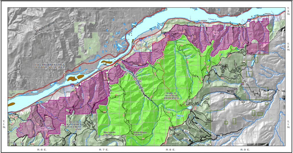
Mark O Hatfield Wilderness – Gorge Face
https://www.fs.usda.gov/Internet/FSE_MEDIA/stelprdb5182601.pdf
What are Recreation Activities in Mark O Hatfield Wilderness?
If you plan for multi-day hiking or backpacking, you can go to Mark O Hatfield Wilderness trails and explore nature’s beauty. Whether you like to walk, hike, have a nature trip, or wildlife watching, you can choose the suitable routes for you. If you want to stay with nature for a longer and more complete path, you are ready to go backpacking.
Visitors can also enjoy delightful adventures such as horse riding, fishing, wildlife watching, and rafting. Make sure to check the rules and regulations before you go.
What Do I Need to Bring Along during Mark O Hatfield backpacking?
That said, you may bring some backpacking gear such as sleeping bags, tent, fuel and stove, weather-appropriate clothing like hot weather hiking pants, hiking boots, water bottle, camping tea kettles and more. Make sure you have everything you need for a long day hiking, including emergencies and hygiene supplies.
On the other note, there are some restrictions applied to recreation use. For example, groups are limited to 12, including both people and animals; campfires and camping are not permitted within 200 feet of Wahtum Lake; campfires are prohibited during June 1 – September 15. More details of restrictions can be found on https://wilderness.net/visit-wilderness/?ID=342
Last but not least, make sure you go camping or build campfires in permitted areas, dispose of waste properly, respect wildlife, be considerate of other visitors while you are visiting Wilderness areas to preserve the nature of Wilderness.
What are Mark O Hatfield Wilderness trails being used?
There are almost 200 miles of trails in Mark O Hatfield Wilderness followed by drainage. About 14 miles of the Eagle Creek Trail and Pacific Crest Trail receive most people. If you are a nature lover who is always excited about hiking, camping, or backpacking, Mark O Hatfield Wilderness is an excellent choice for you.
Most people can hike in the loop of more than 16 miles on the Eagle Creek Trail, featuring seven waterfalls, designated campsites, and tunnels. Lots of people go on this trail because of its close position to Portland. If you want quieter tracks, Tanner Buttle, Nick Eaton Ridge, and Herman Creek will try. It’s about 10 to 12 miles for the round trip for each of these quiet trails.
Are you looking for great trails to discover the incredible beauty of Mother of Nature? Let’s consider your priority to see the lake, the cliff, or the track’s difficulty level to decide which one to go. Below are some examples of the best trails in Mark O Hatfield Wilderness.
Indian Point via Herman Creek, Gorton Creek Loop, and Nick Eaton
Indian Point via Herman Creek
https://www.alltrails.com/trail/us/oregon/indian-point-loop-trail?u=m
Indian Point via Herman Creek, Gorton Creek Loop, and Nick Eaton is 11.7 km long and rated as difficult. It takes us about more than 5 hours to complete the route. This trail is among the most heavily trafficked ones and located near Cascade Locks in Oregon. Most people use this trail for nature trips and hiking from April to November.
Here you can find some excellent viewpoints of the Gorge Face with Mt Hood. Many people like hiking on this trail because of its relatively good steep and decent challenges. The track is pretty overgrown. Thus you may need to wear pants and socks to avoid getting scratches from bushes. Plus, bring some water and snacks to prepare for the challenges of a difficult trail.
Chinidere Mountain via PCT and Chinedere Cutoff Trail
Chinidere Mountain via PCT and Chinedere Cutoff Trail
https://www.alltrails.com/trail/us/oregon/wahtum-lake-to-chinidere-mountain?u=m
Chinidere Mountain via PCT and Chinedere Cutoff Trail is a shorter trail with 6.3 kilometers long. It takes more than 2 hours to complete this trail. This trail is a moderately trafficked loop one and is also rated as moderate. The track features a lake located close to the Hood River in Oregon. People mostly use this trail for hiking, nature trips, walking, and birdwatching from April to October.
People like hiking on this trail because the challenge is a reasonably decent workout on the way up. You can enjoy a spectacular view and fantastic loop from the mountain peaks to the Lake Wahtum. Thus many people go camping at Wahtum during the weekend. There is also an incredible view when you find the steep climb up to Chinidere.
There are bugs and mosquitos in some muddy sections of the PCT, so you may need to bring a mosquito repellent along. Plus, we would suggest going on a clear day that you can have a rewarding view of all the hard work you put in.
Herman Creek Trail
Herman Creek Trail
https://www.alltrails.com/trail/us/oregon/herman-creek-trail?u=m
Herman Creek Trail is 31.9 km long, located near Cascade Locks. It is estimated at 11.5 hours in total to complete this trail. This trail featured a waterfall and was rated as challenging because of its steepness. However, it is manageable for most people, even dogs. The track is usually used for hiking, bird watching, and nature trips from April to October.
Many people like hiking on this trail because of challenges by its manageable steepness in some places. You can enjoy seeing beautiful bridges, waterfalls, and creeks along the way. This trail is an excellent option to make a loop with Indian Point, Casey Creek, and Nick Eaton Trail.
Wahtum Lake to Tomlike Mountain
Wahtum Lake to Tomlike Mountain
https://www.alltrails.com/trail/us/oregon/wahtum-lake-to-tomlike-mountain?u=m
This trail is 12.1 kilometers long, located in Hood River in Oregon. It usually takes you about more than 4 hours to complete the route. This track is rated as a moderately trafficked loop trail. People use this trail for hiking, bird watching, and nature trips from April to October.
People love hiking on this trail because of its great view on the top. You can expect an unstable and steep terrain on this trail. Thus it can be an excellent workout for mental and physical change. You may need to download a GPS map and bring along a mosquito spray to go on this trail.
Wyeth to Gorge Trail
Wyeth to Gorge Trail
https://www.alltrails.com/trail/us/oregon/wye trail th-to-gorge-trail?u=m
This trail is 6.4 kilometer long, located near Cascade Locks in Oregon. It features a river and is considered a good and easy route for all skill levels. People use this trail to walk, hike, run, nature trips all-year-round.
This trail is mostly through the forest, but it leads to nowhere that no signpost indicates you reach the track’s end. The vast majority of this trail is on a rocky ledge. You can find some views of the Gorge but no outstanding view as other hiking trails.
Final Words
In a nutshell, if you are looking to discover the incredible beauty of Mother of Nature, Mark O Hatfield is an excellent choice to go. Here you can hike or go backpack through different trails to not only enjoy a great healthy workout but also a breathtaking panoramic view of nature.
Hopefully, with an aim to provide more information about different trails that have beautiful bridges, waterfalls, cliffs, and creeks, you can decide the most suitable trail to plan going ahead in Mark O Hatfield Wilderness.
FREQUENTLY ASKED QUESTIONS
Question: Is it dangerous to hike in Mark O Hatfield Wilderness?
It’s not so dangerous to hike in the Mark O Hatfield Wilderness area. Some trails can be considered challenging because of its steepness, but it is still a manageable good workout for most people, even some dogs. However, to hike on this trail smoothly, you may need to wear weather-appropriate clothing and hiking boots to protect yourself from some muddy sections.
Question: What are the most used trails in Mark O Hatfield Wilderness?
There are many trails to hike in Mark O Hatfield Wilderness, but the most typical route may be the Indian Point via Herman Creek, Gorton Creek Loop, and Nick Eaton. Many people like hiking on this trail because of its relatively good steep and decent challenges. Plus, you can find some breathtaking viewpoints of the Gorge Face with Mt Hood compared to other hiking trails.
Question: What are the recreational activities allowed in Mark O Hatfield Wilderness?
You can do many recreation activities in Mark O Hatfield Wilderness, such as camping, backpacking, wildlife watching, hiking, fishing, horse riding (only on Herman Creek Trails, and Pacific Rest), hunting, and rafting for about 200 miles of trails in the Wilderness.
Question: What are the recreation activities that you can do in Mark O Hatfield Wilderness?
You can do many recreation activities in Mark O Hatfield Wilderness, typically such as camping, backpacking, wildlife watching, hiking, and rafting for about 200 miles of trails in the Wilderness.
Question: Are every person allowed to enter the Wilderness? Any restriction applied?
It is required to have a Wilderness permit from May 15 to October 15 to enter the Wilderness area in Mt Hood National Forest. The licenses are free to receive and can be self-issued at the Wilderness boundaries and the trailheads into the Wilderness area. Having a copy of the permit is required during your whole visit to the Wilderness area. A daily use fee may be applied for some trailheads.
Last but not least, make sure you go camping or build campfires in permitted areas, dispose of waste properly, respect wildlife, be considerate of other visitors while you are visiting Wilderness areas to preserve the nature of Wilderness.